Real Estate Has a Visibility Problem
And the good news is: you can solve much of it already.
When you are assessing a property, a development opportunity or a potential client location, you probably already have access to a lot of information.
You may have listings, transactions, internal sales data, local knowledge, valuation reports, spreadsheets, market studies and online portals. The problem is rarely the lack of data.
The problem is that the data is scattered. It sits across different sources, formats and teams. It is often difficult to compare. It takes time to access. And, too often, it only becomes available after someone requests a bespoke study.
But the market does not wait for a report. Property markets change continuously: prices move, neighbourhoods evolve, new competitors open, retail centres gain or lose relevance, traffic patterns shift, and the profile of people living, working and visiting an area changes.
To make better decisions, you need a more continuous and more geographic view of the market.
Property is local. Your market intelligence should be too.
A national average tells you very little about the value of a specific area. Even a regional average can hide major differences between neighbouring locations. Two areas may have similar population, income or housing stock, but very different demand dynamics, transaction values, residential profiles, accessibility or competitive context.
That is why local context matters. With Mapidea, you can already explore residential transaction prices in England and Wales at MSOA level, including yearly data since 2024. You can see where values are increasing, where markets are stabilising and where nearby areas are moving in different directions.
But the real value comes when you add context. You can combine transaction prices with Census 2021 data, housing and household characteristics, population profiles, Output Areas, LSOAs and MSOAs, and the Output Area Classification geodemographic segmentation.
Instead of simply asking:
“What is the average price in this area?”
You can start asking:
“Who lives here?”
“How is this area changing?”
“What type of residential market is this?”
“Which nearby areas are genuinely comparable?”
“Where is demand likely to emerge next?”
That is a much more useful basis for investment, valuation, development, agency and client advisory work.
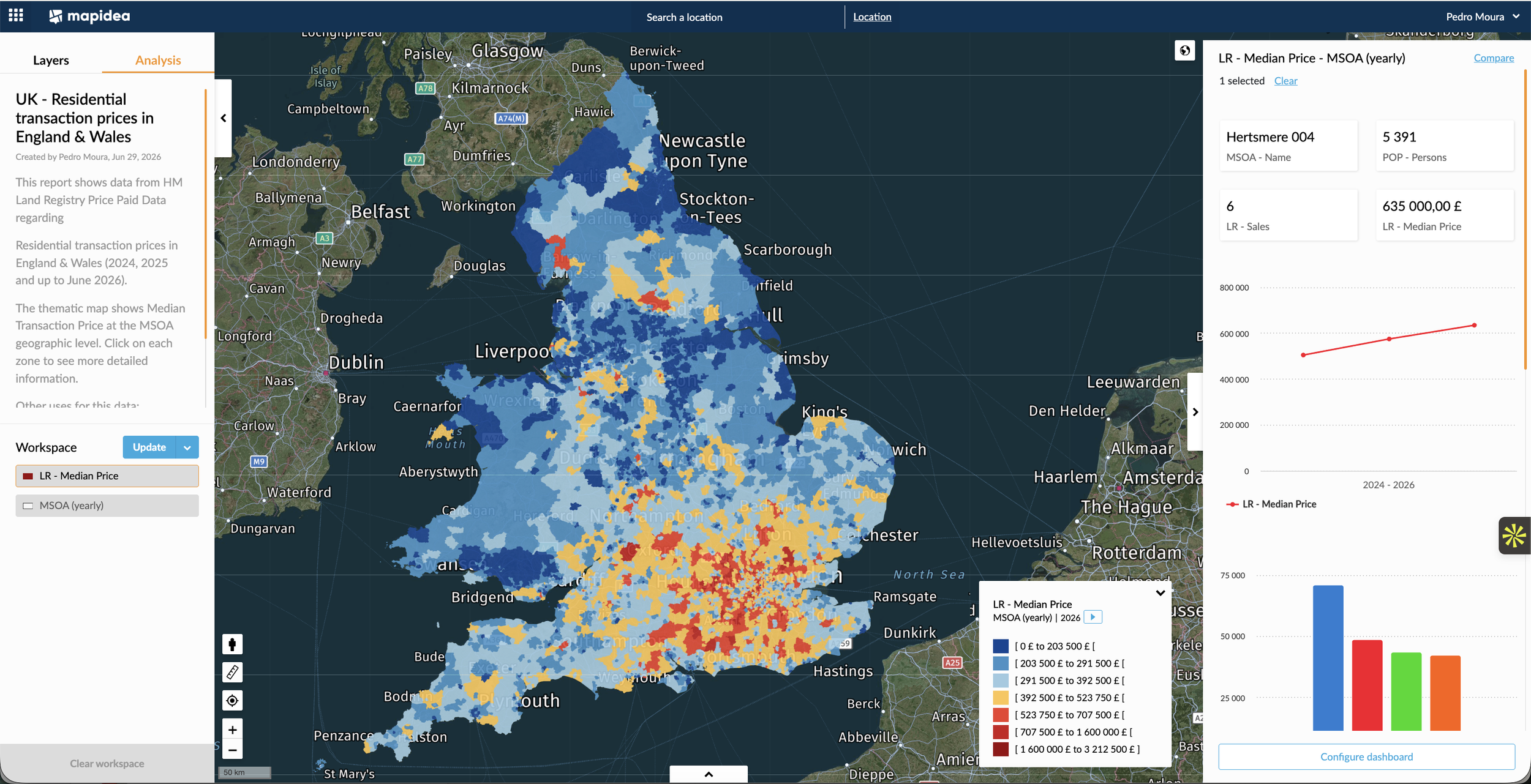
Mapidea Analysis - UK - Residential transaction median prices in England & Wales (HM Land Registry Price Paid Data)
A commercial asset is never just a building.
The same principle applies to offices, retail, industrial, logistics and mixed-use assets. A property does not exist in isolation. Its value is influenced by the market around it.
You need to understand the surrounding commercial stock, occupier mix, retail environment, accessibility, local demand, transport, footfall, competition and the wider trajectory of the area.
With datasets such as the VOA Non-Domestic Rating List, it is already possible to analyse commercial property stock, use classes, rateable values, floor areas and the relative concentration of office, retail and industrial activity. You can combine this with retail-centre boundaries and indicators, catchments, high-street typologies, POIs, mobility, traffic and footfall data.
And you can bring in your own internal information: published units, client portfolios, sales activity, team performance, leads, transactions and pipeline. This creates a much richer view of the question behind almost every real estate decision:
“What is really happening around this asset, this opportunity or this client?”
This does not need to be a major data project.
One of the biggest barriers in real estate intelligence is the assumption that this type of analysis requires a large GIS project, a specialist team or months of setup. It does not.
Mapidea makes it possible to start with the data you already have, add relevant external datasets and make them available to the people who need to use them. Your investment team can benchmark opportunities.
Your development team can understand neighbourhood change and market gaps.
Your agency and advisory teams can build stronger client studies.
Your asset-management teams can monitor change around existing assets.
Your commercial teams can understand where leads, transactions and activity are concentrated.
And leadership can compare markets, territories and portfolio exposure through one shared view.
The purpose is not to replace local expertise or professional judgement: it is to give every team a better starting point, a shared market reality and less dependency on manual research.
The examples are from England and Wales. The principle applies everywhere.
This article uses England and Wales because the available datasets make it particularly easy to demonstrate the approach: detailed residential transaction data, Census information, geographic statistical areas, geodemographic segmentation and commercial-property datasets can all be combined at meaningful local scales.
But the principle is not specific to the UK. Every market has its own data ecosystem. The available geography, coverage, update frequency and level of detail may differ by country, city or sector. In some places, data may be more fragmented or less accessible.
That is precisely where Mapidea can help. Mapidea can bring together the best available external datasets for a market, combine them with your own internal information and make the result accessible through a single, business-friendly geographic workspace.
The question is not whether every market has exactly the same data. The question is whether you are using the data that does exist to understand your market better than you did yesterday.
The opportunity is not more data. It is better market awareness.
Real Estate has always been geographic. The opportunity now is to make that geography visible, shared and continuously usable across your organisation.
You can already move beyond static reports, isolated spreadsheets and occasional market studies. You can see market reality across geography and over time.
And you can use that visibility to make better decisions, support better client conversations and continuously improve the performance of your operation.
Reach out for more information.