Mapidea GeoProcess: Automate Your Geographic Analysis and Reports
A new no-code capability to turn recurring location analysis into repeatable business processes.
Many organisations regularly need to answer similar location-related questions: whether a new site is viable, what potential exists around an asset, how a territory should be prioritised, or what impact a competitor or network change may have.
In most cases, the underlying methodology is already known. Teams know which datasets matter, which geographic rules should be applied, which indicators should be calculated and what should be included in the final assessment.
The issue is that this work is often repeated manually. It may involve analysts, GIS specialists, IT teams or external consultants, and it can require several steps before a business user receives a usable result. This creates cost, delays and inconsistency, particularly when the same type of analysis needs to be carried out for many locations.
We built Mapidea GeoProcess to make these recurring analyses easier to create, run and share.
GeoProcess allows a user to define a complete geographic analysis in Mapidea and save it as a reusable process. No coding, workflows or complications whatsoever. The user can specify the relevant input, such as a location or an asset, together with the data layers, geographic operations, indicators, calculations, maps and outputs that should be produced.
Once created, the GeoProcess can be run again whenever needed. A user selects the relevant input, Mapidea executes the defined analysis automatically and presents the resulting outputs. The analysis can also be exported into a structured PDF report based on a predefined template.
Geographic automation without programming, GIS expertise or IT support
What makes GeoProcess particularly important is that it does not require technical development.
Users do not need to write code, configure GIS software or involve IT teams to create a new automated geographic workflow. A business user can create a GeoProcess in the same environment and with the same logic used to build a normal Mapidea analysis.
This means that the people who understand the business question best can also define how it should be assessed.
They can decide which data is relevant, how the geographic context should be analysed, which rules and thresholds should apply and how the final result should be presented. The process remains transparent and can be reviewed or improved as the business evolves.
Rather than forcing organisations into a generic scoring model, GeoProcess allows them to operationalise their own methodology.
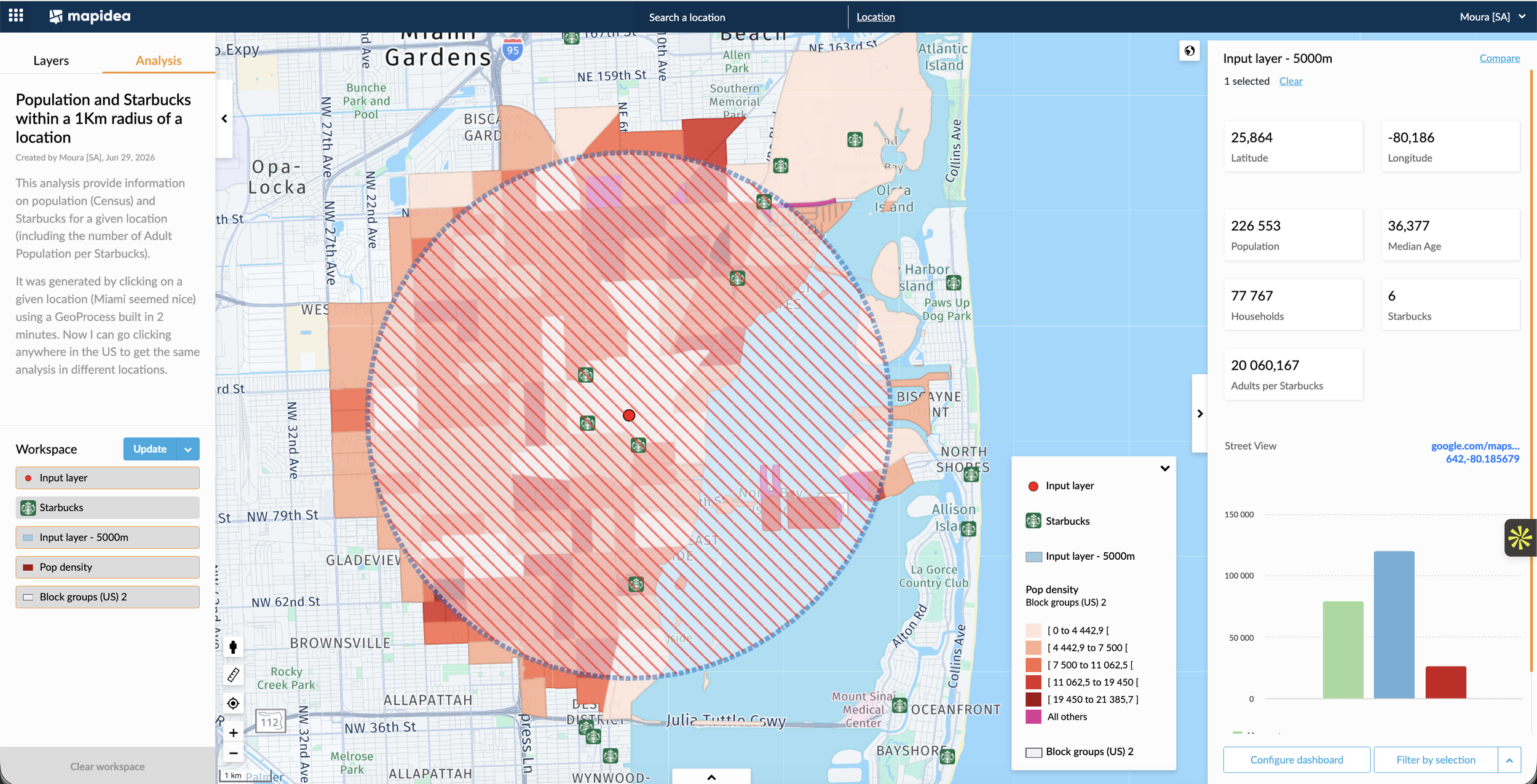
Population and Starbucks within a 1Km radius of a location. Just double click on a location and your this Geoprocess gives you the resulting analysis.
Reducing the effort and cost of recurring analysis
The cost of geographic analysis is rarely limited to data access or software licences. A significant part of the effort comes from repeating the same manual work: preparing maps, creating buffers or catchments, combining datasets, calculating indicators, formatting outputs and producing reports.
GeoProcess reduces this repetitive work by making the full analysis reusable.
It enables organisations to apply the same methodology consistently across many candidate locations, existing assets, territories or scenarios. It also reduces dependency on specialist resources for routine requests, allowing analysts and experts to focus on more complex work where their judgement adds the greatest value.
For business users, this means faster access to relevant geographic insight. For organisations, it means lower effort per assessment, more consistent decision-making and a clearer way to scale location intelligence across different teams.
Store Location Intelligence: the first GeoProcess application
The recently launched Mapidea Store Location Intelligence module is the first practical example of GeoProcess in action.
A retailer can enter a candidate store location and automatically assess its business potential using a transparent model. Mapidea combines the relevant demand, competition, accessibility, catchment, mobility, cannibalisation and internal-network indicators, producing a structured location assessment and a corresponding PDF report.
The model can be reviewed and improved over time, but the core workflow does not need to be rebuilt whenever a new location is evaluated.
This is an important shift. What would previously require a bespoke study can become a controlled, repeatable and much faster process.
A capability that can be applied across many industries and business cases
Although Store Location Intelligence is focused on retail expansion, GeoProcess can support any recurring business process that depends on understanding the reality around a location.
A real estate team may use it to generate standard local-market studies for assets, development sites or client opportunities. A bank may use it to assess the role and potential of branches, ATMs or service points. Healthcare providers can create structured assessments for clinics, pharmacies or other service locations. Logistics companies can evaluate potential locker, pickup point, depot or micro-hub sites using an agreed methodology. Public services can get the geographic context of a location for a new equipment or understand the profile of the population in a specific place.
The specific data and indicators will vary, but the principle remains the same: a repeatable geographic question can be turned into a reusable process, made accessible to the people who need to use it.
Extending Mapidea’s core philosophy
Mapidea has always been designed to make geographic intelligence accessible beyond specialist GIS teams, with a focus on regular business users.
GeoProcess extends that principle by allowing users not only to run analyses, but also to create repeatable processes that reflect how their organisation makes decisions.
It removes a major barrier between a business question and the geographic analysis required to answer it. Instead of commissioning a new workflow every time, organisations can capture their existing methodology, make it reusable and improve it continuously.
The result is not simply automation for its own sake. It is a more practical way to make location intelligence part of daily business decision-making, with less effort and greater consistency.
GeoProcess enables organisations to build geographic processes once, apply them many times and make their own methodology available wherever it is needed.
Talk to us if you want to try it out.